Saharan Dust Expected to Blow Onto Portuguese Mainland
- @ Cynthia Adina Kirkwood

- Feb 23
- 2 min read
Dust from the Sahara Desert is expected to blow onto the Portuguese mainland on February 24. The Portuguese Institute of the Sea and Atmosphere warned of "the possibility of implications for air quality and effects on health".
The suspended particles from North Africa are forecasted to reach the Madeira archipelago first, on February 23, then head toward the mainland "gradually progressing from south to north, within a southerly flow, defined by the anticyclone located over the Iberian Peninsula and by the approach of a cold front to the continent", reported the Portuguese Institute of the Sea and Atmosphere (IPMA), according to SAPO (February 23).
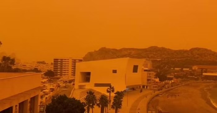
The dust often changes the color of the sky to an orange hue.
Although the phenomenon occurs at high altitudes, it still may cause some dust deposits on cars, windows, and solar panels in northern Portugal during February 24 and 25, reported Público (February 23).
"The latest CAMS forecast charts show that the plume will cross initially southern and central Portugal during this Tuesday, and it will continue northward" into Spain, France and northern Europe, said Mark Parrington, a senior scientist at the Copernicus Atmosphere Monitoring Service (CAMS), according to Público.
The forecasts indicate that the plume will particularly affect the Canary Islands and Madeira before continuing its path towards the Iberian Peninsula and Northwest Europe.
A second branch is expected to move towards South America. This type of dust transport is typical at this time of year, but the scale of the current episode warrants the attention of experts.
"Large-scale aerosol outflow into the North Atlantic is not uncommon at this time of year, with seasonal biomass burning in Equatorial Africa typically peaking between January and March, and Calima winds (the phenomenon which occurs when fine sand and dust particles from the Sahara are transported by prevailing winds) carrying dust from the Sahara across the ocean. The high intensity of this particular episode is significant, as our forecasts show a plume reaching northwestern Europe," said the scientist Mark Parrington.
The Portuguese Institute of the Sea and Atmosphere (IPMA) explained that this type of event can reach the mainland and the Madeira archipelago a few times a year. It said that it happens after the “occurrence of storms”, according to Expresso (March 15, 2022).
“These storms give rise to strong winds that, when blowing over desert surfaces, lift the lightest particles from the ground. The dust/sands are then transported through the atmospheric circulation.”
In the case of the most vulnerable group -- children, the elderly, and patients with chronic respiratory problems such as asthma and cardiovascular issues -- it is advisable to stay inside buildings and, preferably, with closed windows, directed the Directorate-General of Health (DGS), according to SIC Notícias (February 23).
Until the passing of the phenomenon, the Directorate-General of Health (DGS) recommends that the general population:
1. Avoid exertion;
2. Limit physical activity outdoors,
3. Avoid exposure to risk factors, such as tobacco smoke and other products that cause irritation.
Chronic patients should maintain their ongoing medical treatments.
In the case of an aggravation of symptoms, please call Health Line 24 at (808 24 24 24) or seek medical attention.


Comments